Location of the Focal Region and Hypocenter of the California Earthquake of April 18, 1906
Anthony Lomax
Anthony Lomax Scientific Software, Mouans-Sartoux, France - www.alomax.netMarch, 2006
Definition of 1906 focal volume
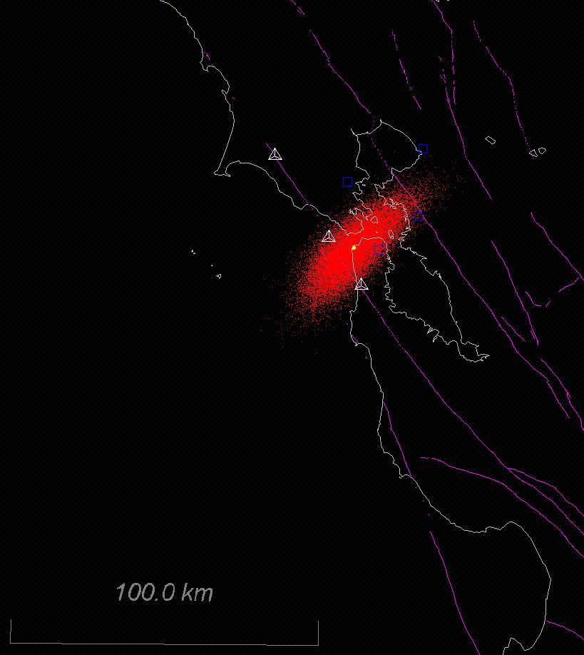
Lomax (2005) determined
probabilistic hypocentral locations for the foreshock and mainshock of
the 1906 California earthquake through reanalysis of arrival-time
observations in conjunction with modern wave-speed models and event
location techniques. The Lomax
(2005) “preferred”
mainshock location has a large uncertainty volume (pdf), but is consistent with the
association of
initial rupture of the 1906 earthquake with an extensional right-bend
(e.g. Lawson, 1908) or stepover (e.g. Zoback et al., 1999) in the
submerged San Andreas Fault (SAF) system offshore of the Golden Gate.
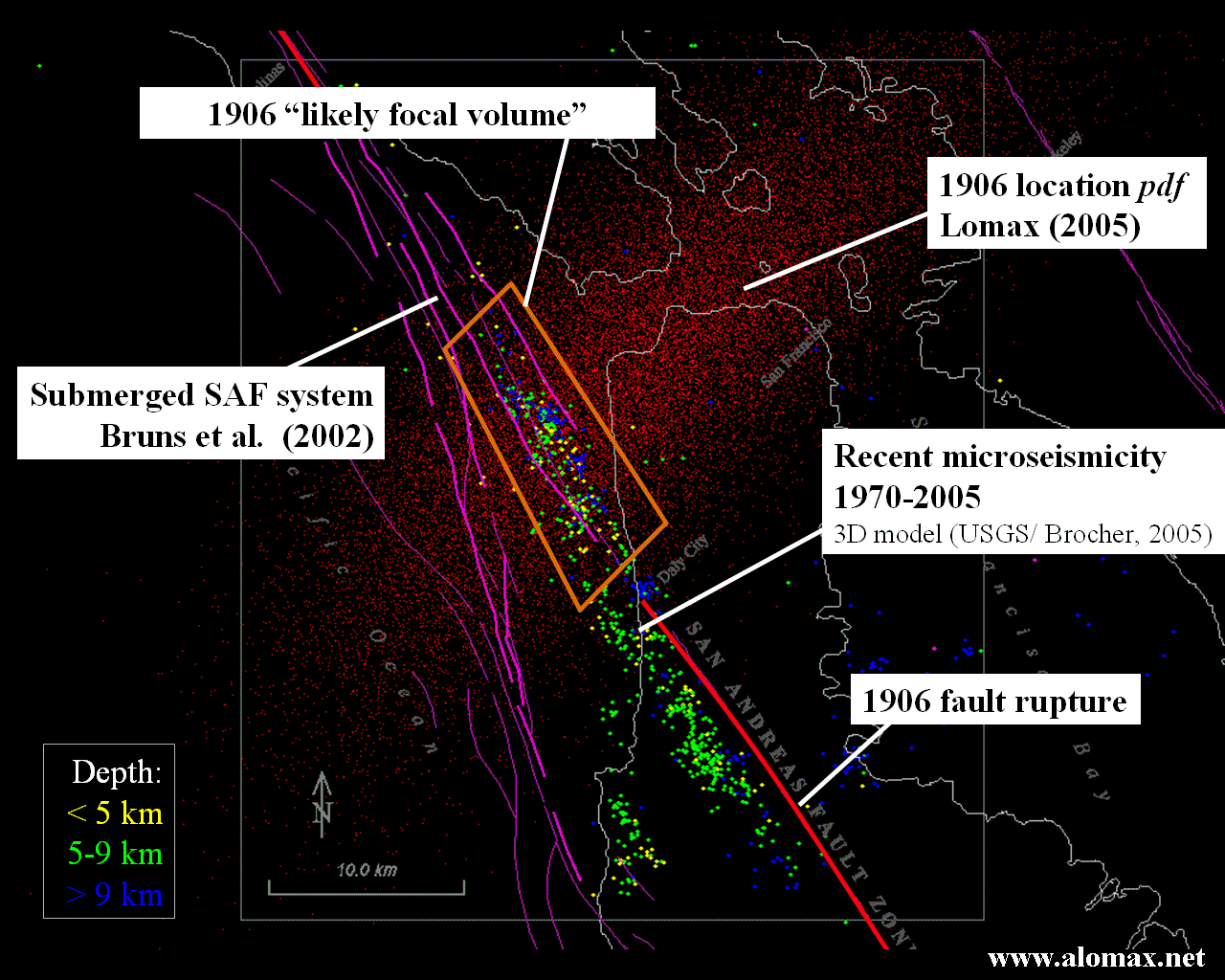
Since the observed surface rupture for the 1906 earthquake occurred along the SAF (e.g. Lawson, 1908), we may assume that the focal region for the 1906 mainshock is located within the SAF zone. Then, an upper bound on a likely focal area is given by the intersection of: a) the SAF zone (as defined by the area between the SAF and the Golden Gate Fault in Bruns et al., 2002), b) the locations of recent micro-earthquakes in the area, and c) the uncertainty volume (pdf) for the Lomax (2005) “preferred” mainshock location. This area is bounded approximately by a polygon with corners at 37.79ºN-122.61ºW, 37.82ºN-122.57ºW, 37.71ºN-122.48ºW, 37.67ºN-122.53ºW, and center near 37.75ºN-122.55ºW (Figure showing 1906 focal area). This likely focal area extends northwestwards from offshore of Lake Merced to offshore of the southernmost Marin Peninsula. The southeast end of this area is a few kilometers to the northwest of the 1906 epicenter near Daly City of Bolt (1968), and near the proposed SAF stepover of Zoback et al. (1999).
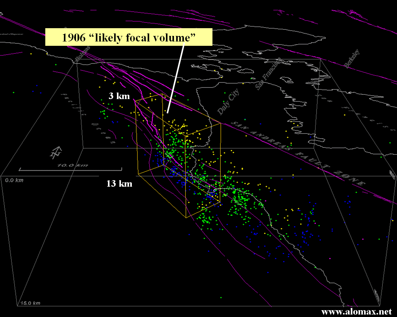
We can constrain a likely
focal volume, including depth, by assuming that the 1906
mainshock hypocenter is within or at the bottom of the seismogenic zone
defined by recent micro-earthquakes, as has been found for a number of
recent, large earthquakes on the San Andreas Fault system, e.g.
Morgan Hill, 1984 (Cockerham and Eaton, 1984), Loma Prieta, 1989 (Dietz
and Ellsworth, 1990), and Parkfield, 2004 (Langbein, et al.,
2005). With this assumption, the depth range of recent
micro-earthquakes in the likely focal area implies a 1906 focal
depth between a few kilometers and about 13 km (Figure showing 1906 focal volume).
1906 hypocenter
The likely focal volume defined above gives the best
available description of the location of the 1906 earthquake
focus. The
center point of this volume and an associated uncertainty give a best
estimate for the
hypocenter of the 1906 California earthquake:
Epicenter: 37.75ºN, 122.55ºW (+/-7km along strike of SAF, +/-2.5km perpendicular to strike of SAF)
Depth: 8km (+/-5km)

Maps showing 1906 epicenter: (Google - MapQuest)
For Google Earth users:
- to view the 1906 epicenter click here (or save the Placemark kmz file available here and drag it into My Places).
- to view the the 1906 source area, faults and recent earthquakes click here (or save the Image Overlay kmz file available here and drag it into My Places).
See also:
References:
- Bolt, B.A., (1968). The focus of the 1906 California earthquake, Bull. Seism. Soc. Am. 58, 457-471.
- Brocher, T.M., (2005). Compressional and Shear Wave Velocity Versus Depth in the San Francisco Bay Area, California: Rules for USGS Bay Area Velocity Model 05.0.0, U.S. Geol. Surv. Open-File Rept., 2005-1317.
- Cockerham, R. S., and J.
P. Eaton, (1984). The April 24, 1984 Morgan Hill earthquake and
its 2 Mar 2006 12/26 aftershocks, in The
1984 Morgan Hill, California Earthquake, J. Bennett and R.
Sherbourne (eds.), Sacramento, Calif.,
Calif. Div. of Mines and Geol. Spec. Publ. 68, 209-213.
- Dietz, L.D., and
Ellsworth,
W.L., (1990). The October 17, 1989, Loma Prieta, California,
earthquake and its aftershocks: Geometry of the sequence from
high-resolution locations, Geophys.
Res. Lett., 17,
1417-1420. DOI:10.1029/90GL01000.
- Langbein, J., R. Borcherdt, D. Dreger, J. Fletcher, J. L. Hardebeck, M. Hellweg, C. Ji, M. Johnston, J. R. Murray, and R. Nadeau, (2005). Preliminary report on the 28 September 2004, M 6.0 Parkfield, California earthquake, Seism. Res. Lett. 76, 10-26.
- Bruns, T.R., A.K. Cooper, P.R. Carlson, and D. S. McCulloch, (2002). Structure of the Submerged San Andreas and San Gregorio Fault Zones in the Gulf of the Farallones off San Francisco, California, from High-Resolution Seismic-Reflection Data, in Crustal Structure of the Coastal and Marine, San Francisco Bay Region, California, T. Parsons (ed.), U.S. Geol. Surv. Prof. Paper 1658.
- Lawson, A.C., Chairman (1908). The California earthquake of April 18, 1906, report of the State Earthquake Investigation Commission, Carnegie Institution of Washington Publication 87, 2 volumes, (reprinted 1969).
- Lomax, A. (2005). A Reanalysis of the Hypocentral Location and Related Observations for the Great 1906 California Earthquake, Bull. Seism. Soc. Am., 95, 861–877.
- Zoback, M. L., R. C. Jachens, and J. A. Olson (1999). Abrupt along-strike change in tectonic style: San Andreas fault zone, San Francisco Peninsula, J. Geophys. Res., 104, no. B5, 10,719–10,742.
[ Back ]