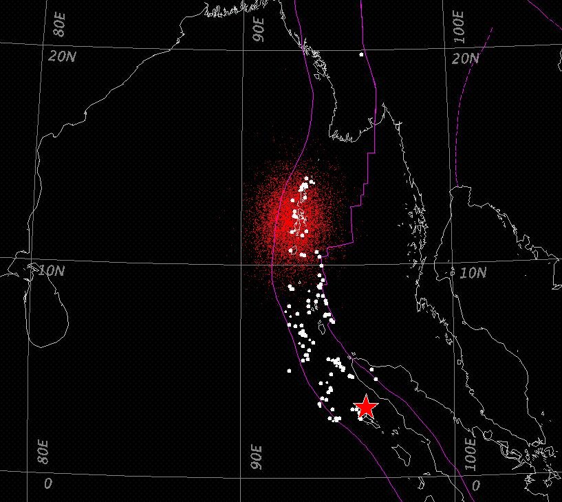
For Google Earth users: to view this figure as an Image Overlay click here (or save the Image Overlay kmz file available here and drag it into My Places).
The 26 December 2004, Mw=9.0,
South Asia earthquake caused a tsunami which devastated coasts around
the eastern Indian Ocean within 3 hours. Tsunami hazard warning
and emergency response for future large earthquakes in this and related
regions would benefit greatly if knowledge of the extent of earthquake
rupture were available within minutes after the event. Currently
the size and extent of rupture of very large earthquakes are first
estimated from moment tensor determinations based on long-period
seismic recordings and from examination of aftershock locations; these
estimates are not available until several hours or more after the
event.
Seismic P waves contain
information on the earthquake
rupture and are the earliest signal to arrive at distant recording
stations. Within about 15 minutes after the event the arrival
times of the initial P wave are routinely used to locate the point of
initiation of earthquake rupture, or hypocenter. The first
available information about the termination of rupture is contained in
the last P-wave energy radiated from the source. Here we
introduce a method to extract arrival times for this energy through
analysis of the shape of the short period, P-wave signal. We use
these arrival times to estimate the location of rupture termination in
the same manner as for the hypocenter location. The required P
wave recordings from global seismic stations are available about 20 to
30 minutes after an event. A few minutes later, this procedure
provides an estimate of the rupture-termination location, and
consequently the extent of rupture for the earthquake, and the rupture
duration. This information can aid in rapid assessment and
modeling of tsunami hazard and of damage distribution.
Application to the 2004,
Mw=9.0, South Asia earthquake gives a rupture
termination location near the Andaman Islands, about 1100 km
north-northwest of
the hypocenter, and a rupture duration of about 8 minutes. These
results imply mainshock rupture throughout the zone delimited by early
aftershocks and an average
rupture velocity of about 2.3 km/s.
Below: Map showing results for the 26 December 2004, Mw=9.0, South Asia earthquake. A density cloud (red cluster of points) indicates the pdf for the termination of rupture location; this location is more likely to be in the denser regions of this pdf cloud. Also shown are the mainshock hypocenter (red star), aftershocks located by NEIC within one week of the mainshock (white dots), and principal plate boundaries (violet lines).

For Google Earth users: to view this figure as an Image Overlay click here (or save the Image Overlay kmz file available here and drag it into My Places).
See also:
Anthony Lomax, Anthony Lomax Scientific Software, Mouans-Sartoux, France, anthony@alomax.net, www.alomax.net